Tagging in the map is used both for:
- Linking Map layers (specifically the features on that layer) to fields in our inspection forms, so that your updated map features display as options in the dropdown for that form field
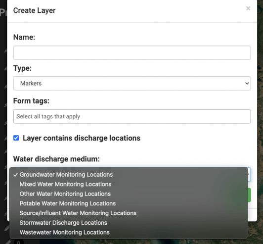
- Identifying which layers on the map contain "Discharge Locations" or water monitoring locations (and what type of water medium is sampled at that location (ex: stormwater, wastewater)), which may not only need to be inspected in inspection forms, but also may need to be sampled with sampling results uploaded for those monitoring locations. Tagging layers as monitoring locations allows us to track your sampling analytical results to the specific points defined on your map.
To add/edit a Form Tag for an existing layer, click on the pen and pad symbol next to the layer you wish to edit.


The “Details” tab allows you to edit the layer’s name and the "Tags" tied to that layer. As mentioned above, many of our forms grab data from layers of a specific tag, for example, if a form asks you for your industrial activities the choices will be auto-populated with features in layers with the "Industrial Activities" tag.
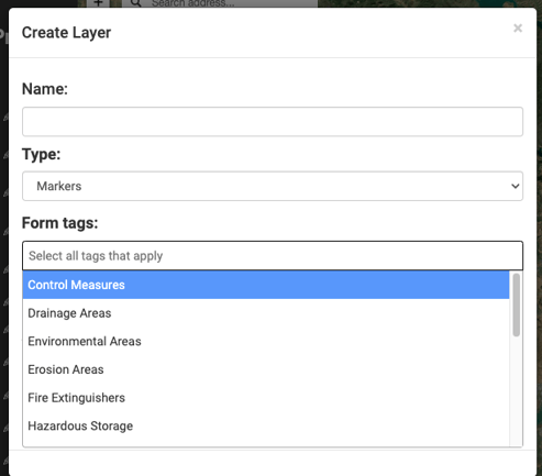
Here is a list of each current Form Tag and examples of potential corresponding functionality:
- Discharge Locations - pulls outfalls into your sampling observation forms for QSEs
- Drainage Areas - may pull areas into your SWPPP Builder, depending on the state
- Tanks - pulls points for HazMat Tank and SPCC inspection forms
- Industrial Activities - pulls points for stormwater inspection forms
- Potential Pollutants - pulls points for stormwater inspection forms
- Fire Extinguishers - pulls points for fire extinguisher inspection forms
- Water Monitoring Location - pulls points for water sample results and water logs
Current tags that act as both Form Tags & Monitoring Location tags are:
- Stormwater Discharge Locations - pulls outfalls into your sampling observation forms for QSEs & stormwater monitoring results
- Wastewater Monitoring Location - pulls points for wastewater sample results and wastewater logs
- Groundwater Monitoring Locations - pulls points for groundwater sample results
- Mixed Water Monitoring Locations - pulls points for mixed sample results
- Potable Water Monitoring Locations - pulls points for potable water sample results
- Source/Influent Monitoring Locations - pulls points for source/influent water sample results
- Other Water Monitoring Locations - pulls points for other water sample results
Other Form tags available are below. If you have any questions on these or would like to use them in your own custom form, please email help@mapistry.com:
- Impervious Surfaces
- Control Measures
- Environmental Areas
- Erosion Areas
- Industrial Activities
- Non-Stormwater Discharge (NSWD)
- Receiving Waters
- Sector Requirements
- Spills
- Stormwater Conveyance
- Wells
End of Article
Support
If you have any questions or need further assistance, please e-mail help@mapistry.com.